Are you a new developer looking to develop a plot of land? Are you dealing with plots of land owned by others?
If so, a land survey will be a useful asset.
A land survey establishes boundaries on a piece of land. It helps developers know the proper borders to prevent building on a neighbor’s land.
Moreover, a survey will determine if a developer can develop the land effectively. A survey also ensures that construction crews adhere to building codes and zoning mandates.
In many cases, developers hire land surveyors before buying a piece of land. In other cases, owners may want to split the land for further development.
This article will reveal more about land surveys. Let’s explore.
How to Survey Land
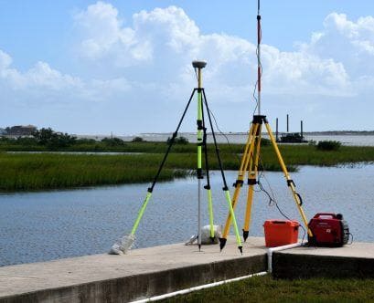
Land surveying requires three key items: a level, a tripod, and a theodolite. A level can be a sight level or a laser level. A theodolite is a telescope used to calculate the vertical and horizontal angles between various points. You’ll see this type of telescope installed on the tripods.
- Note: If you’re entering the survey field, use a high-quality theodolite to get the best results. Clients depend on surveyors for stellar accuracy. Surveyors can derail a project if the survey is inaccurate.
A professional land surveyor is far more valuable than an amateur survey. A professional has the expertise to produce an impeccable survey. They also have additional knowledge of property boundaries, utility rights, and zoning information.
Additionally, the courts don’t recognize amateur surveys. Therefore, choose a professional surveyor in case a lawsuit arises over land disputes.
How to Find a Quality Land Survey Company
You can find a surveyor in the following places:
- Survey Comparison Websites: A comparison website allows you to compare multiple surveyors. As a result, you can find the best match for you.
- Local Companies: You may find a trustworthy local survey company.
Also, choose smaller surveyor companies instead of larger ones. High-level surveyors may not be fully attentive to your land.
A quality survey requires extensive time and preparation. Busy surveyors may miss something crucial, resulting in sub-par work.
More importantly, pick an objective surveyor who has no affiliation with your land deal. An independent company will produce an unbiased survey that all parties can agree to.
Finding the Right Surveyor
Before hiring a land surveyor, read various reviews online. Are they trustworthy? Are their land surveys accurate? Read what previous customers said about the company.
Choose the company that has the most five-star ratings. Avoid companies with low or mediocre ratings.
Plus, choose a surveyor with experience. Additionally, ask questions about their land surveying experience. Experienced professionals may also offer specialized services.
- Example: Perhaps you’re dealing with dampness issues. Therefore, ask a surveyor if they offer dampness surveys.
A sub-standard survey may also offer lower prices. Surveyors offering lower prices may be inexperienced.
They could also have a history of sub-standard work, forcing them to charge lower prices for their services. In other cases, a low upfront rate may come with hidden fees.
Conversely, be aware of professionals who overcharge you. A basic land survey can vary anywhere from $100 to $900, depending on the following factors:
- Geographic location
- Terrain
- Property size
On average, a land survey will cost around $500. A land surveyor who pushes a high price may be trying to rip you off.
Instead, get estimates from multiple companies. Choose the best one that suits your comfort level.
More importantly, ensure the surveyor has accreditation. First, find out if they adhere to RICS regulations. RICS stands for Royal Institution of Chartered Surveyors.
The RICS monitors accredited surveyors. Also, you can report the surveyor to RICS if they engage in unethical practices or produce questionable surveys.
You can also go on the RICS website and search for the name of the surveyor.
Types of Land Surveys
Overall, there are three types of land surveying services:
- Construction
- Boundary/Land
- Geodetic
An engineering survey involves such attributes as construction, maintenance, operations, design, and conception.
Surveys in this category also pinpoint the exact location of roads and existing structures. They’ll also assess the depth foundation to determine if the land is suitable for development.
Further, they’ll collaborate with design teams, pinpointing potential flaws within the conception. They’ll also provide practical advice to help construction crews make the project a reality. You’ll also see land surveyors within the energy and mining sectors.
The land survey process involves three key steps:
- Measuring the land
- Marking the boundary lines within ownership parameters
- Assessing the historical records of the land, including surrounding lands
Finally, geodetic surveying involves large-scale land assessment using satellite and/or aerial imagery. This survey takes into account the earth’s curvature, size, and shape. A geodetic surveyor will use the earth’s surface to make corrections to an existing survey.
In most cases, developers don’t need a geodetic survey. They would need one if the land in question is large enough to require an analysis of the earth’s surface.
What is Land Surveying Overall?
If you’re wondering, “What is land surveying?”, it’s the evaluation of land. Amateurs and professionals can conduct a land survey with the right equipment.
However, developers rely on professional surveyors to provide an accurate assessment of the land. If you need a land survey, hire a professional.
A professional survey is also more legitimate in court. Above all, find a survey company with a solid reputation and a great work record.
Interested in a land survey? Read more of our website to learn about our services.